Frequently Asked Question's?
Through our research into this website's main topic, we have come across some strange and indeed so called historical facts by especially our good friends, the Eelamist.
These include the idea that the Singhalese are in fact Tamil's and Sinhala language is Dravidian but more precisely Tamil.
We the organiser's of this site, thought it was time to start deconstructing these misguided idea's.
Lets begin;
*Question One..Is it true, that their is a map by Robert Knox, which show's a Tamil country covering the area's that the Eelamist's claim?
*Question Two..How did the map of Tamil Eelam come about?
*Question Three..Are the Singhalese and Tamil's linked by DNA, as some Eelamists claim eg on Wikipedia?
*Question Four..Is the Sinhala language an offshoot of Dravidian, more precisely Tamil?
*Question Five..Sinhale, a 11th Century outcome?
*Question Six..Are the Buddhist Monument's in North and Eastern parts of Lanka by Tamil's?
*Question Seven..Is Demala Pattu a Tamil region, as described by Tamil extremist's eg on Wikipedia?
*Question Eight..What are the origins of the Sinhala people?
*Question Nine..Did the British create the united Lanka, as you find it today?![]()
*Question Ten..Can you be native to two different countries?
*Question Eleven..Was Sita really at Seetha Eliya?

*Question Tweleve..The so called Tamil inscription of Tissamaharama ?
*Question Thirteen..The Trinco inscription?
________
Question One..
Is it true, that their is a map by Robert Knox, which show's a Tamil country covering the area's that the Eelamist's claim?
This is a question that we received in the last few day's and is an extremely important one. Their is a map been spread around, strangely enough on Wikipedia and some Tamil sites, that show's this;
 fig,1..This is the map that is been taken by the Eelamist's as proof of a Tamil homeland. This was apparently done by the British cartophotograper, Rob Modern in 1695(Provided by Wikipedia and strangley enough found 'NO' where else but Wikipedia and Eelamist sites hmmmmmm) and when looking at this and reading Knox's book, it is clear and obvious that this cartophotograper, had not read the book by Knox. As otherwise, he would realise his enormous mistake but saying that, it is becoming obvious, how Eelamist's have cleverly taken this map and used the area's that signify the Dutch territories as a Tamil homeland.
This map doe's state Coilat Wannea country but the outline is not all as it seems. That outline, in fact, represent's the Dutch conquered territory.
Here we will quote in the exact word's used and include the page number's, what in fact Robert Knox says;
*Cuttiar, which last together with Batticalaw, and part of Tuncourly, the Hollander took from the King during my being there(Kandy)..Page 2, Part I,Chapter I
This indicates that the majority of the East was well under the control and part of the Sinhala Kingdom and not of any so called Wannea's. Thus from the start, showing the flasehood of the Eelamist's claim.
*Besides the Dutch who possess, as I judge, about one fourth of the Island, there are Malabars, that are free denizens and pay duty to the King for the Land they enjoy, as the King's natural(Meaning Naturalized Foreigner's), subject's do; there are also Moors, who are like strangers, and hold no Land, but live by carrying goods to the Sea-Ports, which now are in the Hollanders hands. The Sea-Ports are inhabited by a mixt people, Malabars and Moors, and some that are black(Negro communities via the Portuguese).
But I am to speak only of the natural proper People of the Island, which they call Chingulays..Page 62, Part III-Chapter I
Cont...
*Discourse of any of these, I shall detain my Readers a little with another Nation inhabiting in this land, I mean the Malabars; both because they are Strangers and derive themselves from another country and also because I have had occasion to mention them sometimes in this book.
These Malabar's then are voluntary Inhabitants in this Island, and have a Country here; tho the Limit's are but small: it lyes to the Northward of the King's Coasts betwixt him and the Hollander. Corunda Wy(Oya), River parts it from the King's territories. Thro this country we passed, when we made our Escape..Page 175, Part IV, Chapter XIII
In Part IV, Chapter's X-XIII, we read the description of his escape from Kandy. This chapter describes, his encounter's with Malabar people. It is clear that this Coilat Country, ruled by a prince who is named as Ciolat Wannea, is near Puttalam. As Arripo is very easliy reached from this so called country. It is also clear, that its a very small area with a very small populace. Comprising of not more than a couple of villages, if even that. It is also stated, that this Pricipalitity is very loyal to the Sinhala Kings in Kandy. This is in fact stated on this particular chapter.
For those are not aware of how these Malabar's came to Lanka, we shall explain. sible explains from Portuguese Records and British;
- In the early 1300's Muslim invader's, Malik Kafur and Kushrukan attacked Madurai and according to Pujavaliya, many Royal families because of these events, arrived in Sinhale as refugee's. The Sinhala King's gave them area's to live in and in time were absorbed in the general Sinhala society, like the Roman's to English society.
- According to the Hugh Neville collection of records in the British Museum, these are the descendents of the 95 warriors brought over from Kanchipura by King Buwanekabahu I. It is said that, they were settled in the villages of the North-Western sea board to safe guard the kingdom. This may have been, because of Muslim expansion in India. Unfortunately though, no exact date is given but can be considered between 1287-1298AD.
Wannia's, according the Pujavaliya, were created after the destruction of the Classical Sinhala Cities of the Anuradhapura and Pulastinagara(the Fort of Pulasti). These were Sinhala cheiftainship's, except for the one created by the South Indian refugees. Please see for detail's of Singhalese Wannia's during the Dutch era..Link
For those that like a challenge though;
I recommend using a map of the Dutch held area's and a Colonial map of Nuwarakalaviya, which is in our Maps section. In between the Dutch and Sinhala King's territory is this so Principality called Coilat Wannea area.
Breaking News...:
We have located the only map, that literally states an area, as a Malabar region and in fact, it matches perfectly with what Rober Knox say's in his book as well...Please see...
 fig,2..This map from 1753 (Dutch Archives) by Bois, J.P.J du, shows the area that is clearly marked out as a Habitat of the Malabars. No other area's, be it Jaffna or East of Ceylon is described as such. This small stripe of land, fits in to what is described by Robert Knox as the Coylat Wannia Country. The area outlined is according to Portuguese, Dutch and early British maps called Panangama(link), which today you find Tamilzed as Panankamam.
According to Knox;
1. This so called country is past Nuwarakalawiya and over the Coronda Oya.
2. Between the Kings territory and the Dutch VOC's.
3. Covers a small area.
4. Close to Aripo, as detailed by Knox.
All these matches the small area oulined and one can see that this small area is all that is listed as a Malabar inhabited region in Ceylon.
Question Two..
How did the map of Tamil Eelam come about?
This is a question, I think allot of people have thought about and we have finally come up with the answer.
In fact it took, Question One(Above) to actually help.
 Fig,3..Show's how it was done.
This is the outcome of investigation into, how Tamil Extremist's created the map of their so called homeland. In laymen's terms, it is the district's that came under both the Portuguese and Dutch put together, that had any presence, in any form of South Indian communities eg the migratory fishing communities of Halawatha. We would expect the Hill Country, would have also have been included, if it wasn't for the fact that all were aware that them Tamil's arrived as estate labour.
In the top left hand side, in yellow is the Dutch area's and the lower left in blue are the maximum area of Portuguese domination. Add these together and put against a map of Sri Lanka today. Taking into consideration, only the parts where Malabar communities have been recorded as been in, eg from the migratory fisher folk in Halawatha & the Tamil Labourers in Batticalao and 'WALLAH', you have the map of Tamil Eelam. Even interior parts match the Eelam map, every ridge is correlated.
Regarding this clever method though, if we were to enlarge this method. Dravidistan, which is the Tamil people's ultimate goal encompasses: South India, Sri Lanka, Maldives, Mauritious, Malaysia, Fiji, Seychelles & Singapore. In other ward's, any where and every where, that their is a Tamil presence in Asia. Wonder why they don't include Britain, Norway, Canada...????
Question Three..
Are the Singhalese and Tamil's linked by DNA, as some Eelamists claim eg on Wikipedia?
It seems that Tamil racists are now using a report published in 1996 by a lecturer of New Delhi University, to establish their claims. We contacted Dr. Gautam Kshatriya, who's report it is and was informed that its an 'anthropological insight'. When asked, how he came upon such an anthropological insight, we were informed that it was after studying myths, legends & historical stories. So in fact, not a scientific research, as we are lead to believe by Eelamist's!
 Click to view...email.
Further, when requesting the list of these item's he used...we are still awaiting that reply!
Lasest report on this topic:
n 2008 Science Daily reported that University of Michigan scientists and their colleagues at the National Institute on Ageing had produced the largest and most detailed worldwide study of human genetic variation - a treasure trove offering new insights into early migrations out of Africa and across the globe. According to this study and the map depicting the findings of the study, parts of Sri Lanka where Sinhalese are the overwhelming majority (areas outside the north and north-east) have a completely different genetic composition to South India. Parts of Sri Lanka where Tamils are the majority (the north and the north-east) show identical genetic composition as South Indians. This shows that Sinhalese are not genetically affiliated to South Indians and have a unique genetic disposition in the region.
It must be said though, that their are many small cases where people of South Indian origin's have been naturally absorbed into Sinhala society eg in the case of the Demala Hat Pattuwa(Small part of what is today Puttalama district) but these were a peaceful process without any trick's or gimmicks. Unlike the assimilation's done by the Dutch and British government's during their occupation...Link
We are also fully aware that Eelamist's are spreading the idea's that Singhalese are in fact Tamil's. As we have stated in this answer, yes Tamil's have been integrated and been absorbed in times past in certain area's eg Demala Hat Pattuwa but also quite a considerable amount of the Sinhalese were absorbed under forced circumstance's during Dutch and British periods.
We also except that at times Kings of Indian decent, have been on the throne but the simple fact is...ALL these foriegn rulers excepted the fact that this Isle is a Sinhala Buddhist nation and tried their utmost to be a good King of Sinhale and adopted the Culture of this nation, as their own eg Nissankamalla & Keerti Sri Rajasinhe.
Trying to use these fact's as an excuse for a Tamil Homeland now, when today's Tamil's are an outcome of Colonialism is ridicules. Then France, Italy and even Norway can claim Britain..As today's English people came originally from France, then other's.
Would such a thing be even asked?
Breaking News....We are excited to say that we have found an American report, which studied the DNA of Tamil's and it shows links with African DNA. Also according to this report, Tamil's are a people who more than likely arrived into the Sub-Continent around 600BCE.
We are endeavouring to gain permission to show this report on here!
Question Four..
Is the Sinhala language an offshoot of Dravidian, more precisely Tamil?
It is in fact an excepted fact by all that Dravidian languages consist's of Tamil, Telugu, Kannada and Malayalam.
 fig,4..The distribution of Dravidian languages.
Sinhala language, which is considered as an Indo-Aryan language, that had developed quite alone and is so unique, that it has been listed as one of the 16 contributing languages to world heritage.
 fig,5..Geographical distribution of the major Indo-Aryan languages (Urdu is not shown because it is mainly a lingua franca with no prevalence as a first language. Outside of the scope of the map is the migratory Romani language(Which in 2003, was found to closely linked to the Sinhala language).
Sinhala has one of the world's most creative alphabets (Link)
The Indo-Aryan languages (within the context of Indo-European studies also Indic) are a branch of the Indo-Iranian languages, itself a branch of the Indo-European language family.
SIL International in a 2005 estimate counted a total of 209 varieties, the largest in terms of native speakers being Hindustani (Standard Hindi and Urdu, about 640 million), Bengali (about 260 million), Punjabi (about 100 million), Marathi (about 90 million), Gujarati (about 45 million), Oriya (about 30 million), Nepali (about 20 million), Sindhi (about 20 million), Sinhala (about 16 million), Saraiki (about 14 million) and Assamese (about 14 million) with a total number of native speakers of more than 900 million. They form a subgroup of the Indo-Iranian languages, which consists of two other language groups: the Iranian and Nuristani.
It must be pointed out though, that today's commonly spoken tongue has had a few foreign words absorbed, these include around 30 Tamil words eg Marchan.
Talking of Tamil though, its important that we all realise how much of it is in fact from Indo-Aryan language;
Indo-Aryan loanwords in Tamil (Link)
Question Five..
Sinhale, a 11th Century outcome?
The answer is 'Yes' and 'No'. Yes the name Sinhale does seem to be a later arrival and most probably around the said period but 'Sinhala' seems to be the older name and records in India alone confirm 2500yrs of this.
The word 'Sinhala' describes the island, its people and its language. G.C. Mendis (1948) suggested that 'Simhala' was the name given to the island and that it was the island which gave its name to the people and the language.
R.A.L.H.Gunawardana suggests that the name was given first to a dynasty, then to a kingdom and finally to a people. There is also a legend which says that the name derives from a tribe of settlers whose leader's name was Simhala. Diviyavadana narrates how Tamradvipa became Sinhaladvipa when conquered by Simhala.
The Sinhalavatthuppakarana supposed to be the earliest extant Pali book in our country does not use the term Lanka to introduce the island. It only uses two alternative terms, Sihaladvipa and Tambapannidipa. This work contains stories from the time of king Saddhatissa (137-119 B.C.).
The Greeks briefly called the island Taprobane and Palesimoundou. These come from 'Tambapanni' and 'Parasamudra.' Except for these two names, all other names given to the island derive from the word 'Sinhala'. The island was called Simhaladipa or Sinhaladipa in the Vedic literature. Allahabad inscription of Samudragupta and the copper plate grant of the western Chalukya king Pulakesin I (89-90 AD) referred to the island as Sinhala.
Also 2nd and 3rd entury inscriptions from Nagarjunikonda(Tamil Nadu) speak of a Sihala vihara and Inscriptions detailing donations made by Sinhalese monks are have been found at Nagarjunikonda. Upasika Bodhisiri of Nagarjunakonda mentions in a 3rd century inscription that Sinhalese monks had converted Kashmir, Gandhara in Afghanistan, China, Kirata, Tosali, Aparanta, Bengal, Vanavasi, Yavana, and the Tamil regions.
Pearls from Sri Lanka were referred to as Simhalaka in Varamihira's Brhatsamhita (5 century AD). Cosmas (6 century AD) said that the island was called Sielediba by the Indians. Seilediba is a transliteration of Sinhaladvipa. Chinese texts of 5th century refer to Sri Lanka as 'Lion Country. Javanese inscription dated 8 century AD refers to Sinhala. In the medieval period Burma and Thailand spoke of Sihaladeepa'.
In Europe, Eratosthenes (230-195 BC) and Ptolemaus (2 century) have spoken of Sinhaladipa. The Greeks also called the island Salike. Ibn Khurdabdhbih (c. 345 AD) in his KItab-al-Masalk-Wal-Mamalik, the oldest available work of Arab geography, refers to the island as Sarandib. Sarandib is a corruption of Sinhaladvipa. Sarandib was sometimes used only for the district in which Adams Peak was situated.
Question Six..
Are the Buddhist Monument's in North and Eastern parts of Lanka by Tamil's?
This is possibly the most ridicules, question that has been asked but we understand why though. We have seen on many sites, were Tamil extremist's claim this.
Pretty much all sites have sil lipi, these are either found to be in Old Sinhala or in Medieval and in quite few cases Modern. The style of Sinhala Buddhist art is unique and can be easily identified. Also the appearance and look of Buddha statue's and also images of gods can be easily identified, if they are of Sinhala origin or not!
Plus...If these monuments were Tamil...Then, why did the every South Indian invader destroy them and the Sinhala King's had to restore them? Why did Tamils during the 60's, 70's & 80's destroy so many of the Buddhist monuments of the East and North? Why did the LTTE have a great interest in destroying the Buddhist Monuments?...If these were in fact Tamil monuments?????
Even the Bamiyan Buddha was destroyed not by Afgans but by Pakistani and Saudi commanders of the Taliban!
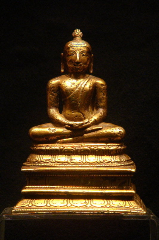 fig,6..A rare and attractive 12th century Chola period bronze image of the seated Buddha from Nagapattinam, Tamil Nadu. Upasika Bodhisiri of Nagarjunakonda mentions in a 3rd century inscription that Sinhalese monks had converted Kashmir, Gandhara in Afghanistan, China, Kirata, Tosali, Aparanta, Bengal, Vanavasi, Yavana, and the Tamil regions.
One must realise that unlike other religions where the images are very much the same, in Buddhism they differ according to the people who built them eg Japanese images are not like Chinese, Chinese ones are not like Thai and Thai images differ from Lao, Cambodian and Burmese. Burmese images differ from Indian and Indian, be it Northern or Southern differ from Singhalese. Simply reason is, all images have the face of the people who make them and that is why, many of the images found in North/East are found with their faces smashed!
Another example is the giant Buddha been built in Kurunegala. As it is been constructed by Tamil labourer's from India. The image has a Tamil look and doesn't bare the look of the Singhalese.
Also majority of all archeological digs, are in fact done with association's with other countries, mostly Britain, Netherlands & Germany. I think, we all know how these countries work and if any Tamil monument's were to be found, the world I am quite sure would know!
So answer is certainly a very BIG...NO...!
Question Seven..
Is Demala Pattu a Tamil region, as described by Tamil extremist's eg on Wikipedia?
First of all, we would like to thank Miss Margaret Hewagama for this question. We took great care in researching this topic including advice from historian's of this area and also importantly, the ancient temples plus obviously Colonial Records.
Concerning the question though, as it was directed after reading the Wikipedia detail's. We though it was only right that we deconstruct what was written their.
So, according to the Wikipedia site;
*Demala Pattu is today's Puttalam District? Wrong ..Please see map of Ceylon from 1751 by the Dutch..Link
What is today's Puttalam District consisted of four area's;
1. Pittigal Corla, 2. Mangoel Corla, 3. Hat Corla, 4. Kalpitiya.
Hat Corla(Korale), consisted of seven pattus; Dambadeni, Katugampola, Weudawili, Demala Hath Patuwa, Hiriyala, Vanni...7th we await the information(Apologies).
The Demala Pattu concerned with, is in fact called Demala Hat Pattu and was found in the Hat Corla. Either Wikipedia doe's not know this or has deliberately ignored it. Each Pattu, consisted of ten villages and not 62 as claimed by those writer's on Wikipedia.
So as in any other Pattu's;
The Demala Hat Pattu was no different and the reason behind its name is that, seven were of South Indian or to be precise of Kerala origin and not Tamil per say and three of Sinhala Origin. These villages were Bangadeniya, Arachchi, Aanavilundawa, Rajakadaluwa, Palugaswewa, Kasala and the other four part's, we again are awaiting this information(Apologies).
These Keralite's though, it is said were given these land's as gift's for their services by Singhalese King's around end of the 15th Century AD but by the time of the arrival of the Colonialist's, they had been naturally absorbed into the Sinhala populace and that is why in the 1824 census, these area's are described by the British, as Sinhala region's.
Additionally, the Munneswaram temple is not a thousand year's old as, said again on Wikipedia but was built during the Dutch period by the immigrant Tamil labour communities and enhanced by the Tamil's via Mannar to the estates, during British rule. The lands that this temple is built on, is in fact apart of the temple property of the Bingriya Rajamaha Vihara.
The above details that we have given is in acual fact slightly wrong. We recently come acorss Portuguese documents, which show the names of all the divisions within the Disavenies. The name Demala Hath Patuwa or just Demala Patuwa, is non existing but a name of Madura is found. This signifies that, this name Madura, obviously to show that, these people came from Madura, were later changed to Demala.
These are the details according to De Queyroz, p46;
The Dissava of the Seven Corla's includesthe following ten....
- Alut
- Pitigal
- Calugambala
- Deuamede
- Urupula
- Curunagala
- Hiriala
- Madure
- Veli
- Magul
"The reason why we call it Seven, when there are ten, it seems, is the corruption of the first Portuguese who misunderstanding a strange language instead of Eti-Corla, which means 'many Corlas' called it Sete-Corla, a word which prevailed afterwards even among the Chingalas."
Question Eight..
We have had quite a few question's regarding the origins of the Sinhala people. This is something that we think is an important subject for all to investigate.
Many of you might be surprised to hear that in fact, their is so far, five stories regarding the origins of the Sinhala people;
1. The Oldest of these is found in the Mahabharata(Mahabharata, attributed to the sage Vyasa, was written down from 540 to 300 B.C) and I quote;
- Mahabharata, Book 1, Chapter 177
When the sage Vasistha was attacked by king Viswamitra's army, Vasistha's cow, Kamadehnu, brought forth from her tail, an army of Pallavas, and from her udders, an army of Dravidas and Sakas; and from her womb, an army of Yavanas, and from her dung, an army of Savaras; and from her urine, an army of Kanchis; and from her sides, an army of Savaras. And from the froth of her mouth came out hosts of Paundras and Kiratas, Yavanas and Sinhalas, and the barbarous tribes of Khasas and Chivukas and Pulindas and Chinas and Hunas with Keralas,and numerous other Mlechchhas.
In the ancient Indian literature, cow is a symbol of earth or land. Thus the myth mentioned above simply means that, these tribes gathered for the protection of sage Vasistha's land, against the army of king Viswamitra.
2. In second place are the recordings of a Solian(Tamil) priest at Mahavihara in the 5th Century AD, called Mahanama. We all know this book has the Mahawamsa.
3. A record of the West, complied during the Tang Dynasty between 629 and 645 AD. The Chiense priest, while at Kancipura in what is today Tamil Nadu, writes after encountering a Buddhist delegation from Sinhala, of two stories;
- That the Sinhala people are born of a union of a Lion and Human. It is said, that their son founded the race not grandson, as stated in the Mahawamsa.
- Is that it was founded by a son of a great merchant.
4. Last of all is a story of the Protuguese & Dutch, who claim a Chinese ancestory to the Sinhala race.
Today though, the Mahawamsa tale is the victor. Unfortunately, but let's look at this;
Does anything apart from the Mahawamsa (which is a dynastic book written in the 5th century by a Soli(Tamil) Buddhist priest), speak off an Indian origin to the Sinhala people? So for one moment, imagine 'NO' Mahawamsa, was ever written.
What then?
Well;
- It is a confirmed fact, that the dental traits of Balangoda man matches today's Sinhala & Veddha population's. This confirm's a direct connection with 40,000yrs of history.
- Their are sel lipi refering to Kuveni, her father, Kavantissa and 14 by Gamani himself but 'No' evidences of a Vijaya or even an Elara. Who in fact occupied Anuradhapura for 40years, so why is their nothing?
Is the aspect's of Sinhalese culture unique? Yes..language, dances, foods, dress, music, the unique form of Sinhala Buddhism, custom's & even attitude's. This show's that the Singhalese, are of this soil and of non other and had developed a unique and advanced civilization's that is on par with that of China and Egypt. Otherwise, it is logical to think our way's, should be in India too!
Question Nine..
Did the British create the united Lanka, as you find it today?
This is something we have encountered by Eelamists to a great extent and in fact at the Global Tamil Forum. This was in fact their main claim for a reason for seperate state.
This is though is a flasehood, as we will show using chronological data covering the periods of 11th Century and onwards;
11th Century-Inscription by the Sinhala raja Parakramabahu the Great and its regarding ship wrecks and taxes on Urathota(Kayts). According to Dr. Karthigesu Indrapala, the editor of this inscription and a former Professor of History of the University of Jaffna, "the fact that this edict was issued not by any subordinate official but by the King himself, shows that the monarch was in supreme control of the Northern most region of the Island".
12th Century-Candrabanu the Javaka's attempts are spoilt at gaining a footing in Sinhale with their expulsion from the North by the Sinhalese King. There are apparent record's, which confirm that the Pandyan King had sent assistance to the Sinhalese for this action.
1236/1270-Parakrama Bahu II, who finally rid the country of these foreign forces.
1359-Medavala inscription, which describes Martanda Mudalis' of Yapanaya as a 'Perumal' or 'Sub-Ordinate' ruler, while the Sinhala king at Gampola is described as 'Vikramabahu Chakravarti Svamin'. Thus ''THE DE JURE RIGHT OF VIKRAMABAHU TO THE SOVEREIGNTY OVER THE WHOLE ISLAND IS RECOGNIZED BY THE TREATY''.
1447/1450-Prince Sapumal, an adopted son and a general of King Parakramabahu VI of Kotte, subdued the unrest by the Mudali classes in the region in 1447-1450 and was later appointed by Kotte as the governor of the Yapanaya region. According to records seen by the Portuguese, he re-populated the barren Yapanaya with the Sinhalese of Kotte Kingdom.
1517-Treaty between King Dharma Parakrama Bahu and the Portuguese Lawrence d'Almeida, confirms the all area's incl Jaffnapatnam, as apart of the Kotte Kingdom;
'Rightful Lord of the World, fortunate descendent of the Kings of Anu-Raja-Pura, the greatest of all on earth, scion of the Gods in this Island of Ceylon, Rightful Lord of the empire of Cota and of the Realms of Jafanapatao and Candea, God of War in conquering Rebels who are more like women than men, Rightful heir of the Kings of Dambaden and of the greak peak of Adam; preserver of the law of Budduas, vanquisher of the Kings styled Ariavansa, for they are traitors; descendant of the son of the Sun with star on he head; true Master of all sciences, Legitimate descendant of Vigia-Bau, I., the Emperor Paracrame-Bau, in the hear of my Empire 40 years called Segara, am content and it pleases me mightily to give to the Kings of Portugal each year as tribute 400 bahars of Cimmamon, and 20 rings set with rubies that are found in this Island of Ceylao, and 10 tusked elephants on Condition that the present Governor and the Viceroys and Governors who shall succeed Lopo Soarez de Albergaria in the State of India, shall be obliged to favour me and assist me against mt enemies as the Vassal that I am of the Crown of Portugal.'
This treaty shows three very Important facts;
- By the statement 'the Realms of Jafanapatao and Candea', shows that these regions are vey much under the Sinhala Kingdom and 'NOT' an Independant region.
- By the statement 'vanquisher of the Kings styled Ariavansa', shows that the Aria Chakrawathi's were non-existent by this time and Sankili etc are 'NOT' of the Aria Chakrawathi Dynasty and
- The statement 'for they are traitors', shows that the Aria Chakrawathi's were indeed under the Sinhala Kings. Otherwise, they would 'NOT' be 'Traitors'!
1580-Dharmapala's Donation Treaty to the King of Portugal;
The states over which the King of Kotte claimed suzerainty were the Kingdoms of Sitawaka, of the {Seven) Korales, of Candea or the hill-country, and of Jaffna, and also the principality of the Four Korales There also were various Vanniyarships, who were bound bo by tribute to the king of Kotte. These were the two Panamas; Yala; Wellewaya Kosgama; Wellassa; Palugama; Batticaloa; Kottiyar; Trincomalee: and Puttalam. This last and Yala were held by several Vanniyars, Palugama by two, the others by one each. In the kingdom of Kotte itself were three Disawas, one over Matara, one over the Adikariya of Denawaka with the Agras or gem-pits of Sabaragamuwa. and one over the Adikariya of Nuwarakalawiya, the country forming the western half of the present North Central Province and stretching according to our document from Puttalam to Mannar. Apart from this last Adikariya or jurisdiction, the immediate possessions of Kotte are given as 221 korales, which included the south-west corner of the North-Western Province, with a small exception the whole of the Western and Southern Provinces as far as the Walawe River, and that part of the Ratnapura District to the south of the Kalu-ganga with the great villages Gilimale and Bambarabotuwa. The small exception referred to is the half of Hewagam Korale, which belonged to Sitawaka.
1593-The Portuguese state quite clearly that Jaffnapatnam is under the rule of King Rajasinhe I.
1609-Letters from the States-General of United Provinces, and Prince Maurice, sent by Marcellus de Boschhouwer to the Emperor of Ceylon. These letters dated Sept, 15th, 1609. Confirm that Rajasinhe is indeed, very much in charge of Trinco, Jaffna, Mannar, Chilaw, Batecalo and Cotiarama.
1611, July 16th-The King assembles all under his domain, to try work out a war plan on retaking Punte-Gale and Walane. All regions are represented incl Jaffna and all areas of the East.
1612, May 11th-Rajasinhe, gives the Dutch his permission to build a fort at Cottirama(Kottiyar), south of Trincomalee.
1613, March 16th-Under the Command of the Nephew of the Prince of Ouva, as Admiral, and Wandige Nai Hammi as Vice-Admiral. Set sail a fleet of battle ships from Cottiarama, against the Portuguese. These ships returned on the 6th May, 1613. With a bounty of more than 600,000 Livers plus a Portuguese ship.
1613, Aug 18th-All under the Kings command, were ordered to meet, due to worsening health of the King. Represented were all regions incl Jaffna and all regions of the East.
1613, Aug 19th-The Royal Patent to invest the two Princes (Ouva & Migonne), with the Administration of the Empire was read in the Assembly;
Cenuwieraat by the Grace of God Emperor of Ceylon, King of Candy, Settevaca, Trinquenemale, Jafnapatnam, Settecorles, Mannar, Chilaon, Panua, Batecalo, Palugam and Jaele; Prince of Ouva, Dennevaque, Passadon Corle, Velaren, Coromale, Mewatre and Ventane; Duke of Willegamme, Cale, Ody and Jattenore; Earl of Quatre Corle, Harkepatte, Odegodascary, Craiwitty and Batagedre. Peace to all those that read these Presents.
1638-Dutch signed a deal with the Sinhalese King to have berthing rights for their ships in all harbours on the East coast, Trincomalee and Batticaloa during the monsoon rains, proving that the Eastern costal regions belonged to the Sinhalese.
1661, April 29th-Etipola Seneviratne Rajaguru Kumarasinghe, Dissawe of Matale. Retakes the Trimangala Kotuwa(Fort Trincomalee).
17th century-The Dutch VOC was engaged in a war of attrition with the King of Kandy, who had close ties with Ceylon's Buddhist population. There was a narrow tongue of land at Elephant Pass; a fort was built to guard the border with the king's territory. Elephants captured on Ceylon were herded past here to Jaffna to be sold in India, hence the name Elephant Pass.
1672-The port of Trincomalee and the whole of Kottiyar Bay, were granted to the French by Rajasinhe II.
1766-The Dutch-Sinhalese Treaty in 1766(Clauses 3, 5, 6 & 16) and the English-Sinhalese Treaty in 1815 (when total sovereignty was ceded to the British) easily illustrate that the East and the inland parts of Jaffna, were completely under Sinhalese sovereignty.
Clauses;
3. And of all the shores not then occupied by it, to wit on the West from Kaimelle (Maha Oya) to Jaffna district, and on the East from the border of that district to the Waluwe River, to a width of one Singhalese mile more or less, as may be most convenient from the position of hills and rivers;
5. The Coy to recognise the King as Sovereign of the rest of the island;
6. The Coy for love of peace to restore all the lands recently captured, except the shores;
16. Such timber to be delivered at Trincomale and Battikaloa as the Coy may need;
1778-The gifting of near enough of the whole of what is today considered as the Eastern Province to the French. These incl the Ports of Kottiyar, Batticalao and Trincomalee.
1873-Ceylon Administration Report:
1795-6, British forces, took from the Dutch a narrow strip of territory boarding the coast with a fort, but the whole of the interior of Ceylon remained under the rule of a native raja until 1815.
The fact that all these regions, are represented, is proof that it is a Unitary Nation and apart of the Sinhala Kingdom!
Download the .DOC, file for all these plus its references...Link
Question Ten..
Can you be native to TWO different countries?
Answer...NO...;
If one is to read any Tamil website eg about 'Tamil people' on Wikipedia. You find that, they are apparently native to India and North & Eastern parts of Lanka.
Is this possible? Can a race be native to two different nations?
A race can only have one homeland. After all 'Tamil Nadu', does mean Tamil Homeland & according to the Tamil lexicon of the Madaras University, the word Ilam is derived from Sinhale but let's discuss this anyway;
Are today's African's, who are found all over the world, called anything but African's? Are the European's who are found in US, Canada, Australia, Brazil, Cuba etc etc...Do they call themselves natives of these land? even though they have been their for 500yrs or more? No...!
If we were to take the lesser claim of Tamil extremist's, of been in Lanka since Magha. Then that's is 900-800yrs and if we were to acknowledge this idea even for moment, doe's that make them native?
More recently evidence's to when the Tamil people arrived, was quite unknowing said by Professor P. Pushparatnam of the Jaffna University, History Department...Please see(Link)
From the above link, one only needs only to ponder;
Why is it, that the Tamil's of these area's, have no knowledge beyond the British and Dutch periods? Could it possibly be, because they arrived during this era? I leave for you to ponder!
If we were to take the extreme claim of been in Lanka since time began, well ask yourselves;
Is their anything unique to them from their counterparts in India? eg Change of language(Different version's of English in US, Canada, Australia, South Africa etc etc...), dances, foods, religion & practices? The answer is No...Tamil's in Lanka have exactly the same language, foods, dances, costumes etc etc...as Tamil's in India. This is evidence of them been a very very recent arrival. Even their relatives in India, are still known...If they have kept contact for thousands of years, as they claim...Shoudn't that be something in the Guiness Book of Records...???
*Question Eleven..
Was Sita really at Seetha Eliya?
Even though, this question isn's really anything to do with this website's topic. We still thought it as a good question and worth an answer;
The answer is in fact 'NO'. Seetha Eliya has nothing to do with Sita or Hindus in any form what so ever.
The first mention of this area is by the British. To be precise, it is in fact Doyle. Who in his letters, gives the name of this area as Hettha Eliya, which means simply 'the cold outdoors'.
This has been changed by the Tamil labourers to Seetha Eliya, this I would assume because of its soundings eg Kolamba, was changed to Colombo because it sounded like Columbus by the Portuguese.
Today, due to this misinterpretation, temples to Sita and other's have appeared in Nuwara Eliya and its sorounding area's at an astonishing rate.
Also, anyone that has actually read the Ramayana, would know that Sita and residence of Asokavana, was in fact on the Coast line and 'NOT' inland and certainly not up a high altitude mountain ranges!
....If anyone has, any further queries, please let us know and we will try our utmost to investigate. Contact
Please Refresh..Keep updated!
|
||||||
| |
| Northen Province | Eastern Province | Tamil Extremism |
|---|
